Prof Jadu Dash
School of Geography and Environmental Science
Project Lead
Professor Jadu Dash specialises in pure and applied remote sensing, particularly using innovative algorithms to derive information about the state and condition of the ecosystem from Earth observation (satellite) data and study the impact of climate and anthropogenic changes on the ecosystem. He works closely with the European Space Agency and in particular, has a strong contribution to its flagship Sentinel programme. He developed one of the operational satellite land products to estimate canopy chlorophyll content of vegetation and pioneered novel space-time data analysis techniques to derive automatic information on vegetation type and condition. His recent work focusses on utilisation of satellite remote sensing data to answer some of the global developmental changes which ranges from predicting crop yield in in small holder farms in Africa to mapping the distribution of Sargassum Seaweed in across the Atlantic. Prof Dash is the founding director of Southampton Geospatial an interdisciplinary centre for Geospatial excellence at the University of Southampton.
Dr Gareth Roberts
School of Geography and Environmental Science
Co-Investigator
Dr Gareth Roberts is a lecturer specialising in environmental remote sensing. Dr Roberts' research interests focus on the measurement and monitoring of land surface dynamics using optical and thermal remote sensing methods. The former involved the application of bidirectional reflectance function models (BRDF) to characterise land surface change and to model the influence of vegetation biophysical characteristics on remotely sensed measurements. The latter concerns understanding the role of fire in the natural environment and on the utilisation of satellite observations to address questions regarding fire effects and impacts. Dr Roberts is author or co-author of over 45 peer-reviewed journal publications on this work, and two book chapters.
Dr Booker Ogutu
School of Geography and Environmental Science
Co-Investigator
Dr Booker Ogutu is a Lecturer in Remote Sensing in the school of Geography and Environmental Science. Dr Ogutu's research interests lie in the use of Earth Observation (EO) data to characterise terrestrial ecosystems, their processes and dynamics. He is particularly interested in the effects of environmental change on vegetation dynamics and their impact on the global carbon balance. Additionally, Dr Ogutu is interested in the application EO data to understand the impacts of climate change on agricultural production.
Dr Erin Goh
School of Geography and Environmental Science
Co-Investigator
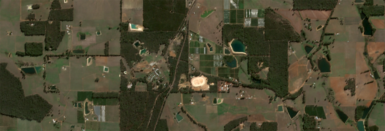
Dr Erin Goh is a research fellow at the School of Geography and Environmental Science. Dr Goh is currently involved in the FruitSense project, which uses earth observation data to improve tree crop production and resilience in Australia's changing climate. She specializes in applying statistical and machine learning methods to remote sensing datasets.
As part of her research, she analyses the data from these datasets to determine the most effective methods of supporting cereal crop production and tree crop resilience during times of climate change. Through the understanding of vegetation dynamics, it provides insight into how best to support farmers and other stakeholders in the agricultural sector. Her work is helping to shape agricultural management in across the globe and providing a better understanding of agricultural sustainability and resilience in the face of climate change.
Dr Shannon Jones
School of Geography and Environmental Science
Co-Investigator
Dr Shannon Jones is a Research Technician in Remote Sensing in the School of Geography and Environmental Science. Dr Jones is interested in the use of remote sensing data to improve our understanding of the natural world, and has a background in space science and meteorology, having completed her PhD studying the propagation of coronal mass ejections from the Sun in satellite imagery. Dr Jones is currently working on the Fruit Sense project, assessing climate risks to tree crop production in Australia. She also has a passion for creating scientific data visualisations and infographics.

Ms Thi Viet Hoai Pham
School of Geography and Environmental Science
Co-Investigator
Hoai is a master student in Applied GIS and Remote Sensing. She has experience building and developing geographic information database systems, as well as remote sensing image processing. Among the main areas of her research are applying machine learning, deep learning algorithm to model the feature classification and object detection using satellite images.
Associate Professor Bryan Boruff
School of Agriculture and Environment
Co-Leader
Dr John Duncan
School of Agriculture and Environment
Co-Investigator
Dr John Duncan is a researcher who has expertise in geospatial software development, data science, and remote sensing. The work of Dr Duncan focuses on 1) understanding climatic and environmental impacts on society through statistical analysis and machine learning, and 2) developing geospatial data collection and visualisation applications for environmental monitoring and decision-making. Dr Duncan has extensive experience working in Australia, South Asia, Sub-Saharan Africa, and Pacific Island countries, collaborating across the research, government, not-for-profit, and private sectors. In addition to research activities, Dr Duncan also develops and delivers training programs related to GIS and geospatial data analysis for a variety of audiences, including university education and government officials.
Dr. Jon Styles
Director of Assimila Ltd
Co-Investigator
Jon is Assimila’s Director and has worked in Earth observation and environmental research for more than 20 years. After gaining a PhD from the University of Reading he worked in technical roles on the data processing systems and cal/val facilities for ERS-1 and Envisat. During secondment to Macdonald Dettwiler and Associates in Canada he worked on the Radarsat ground segment as team leader for the ScanSAR mode processor. He subsequently moved into a management and consulting role and has managed over 50 projects in Earth observation applications development, environment and climate change. In addition to his technical project management and Earth observation expertise, Jon has wide ranging experience in project definition, cost-benefit and impact analysis, strategy development and knowledge transfer. His international experience includes extensive work across Europe as well as in the USA, Canada, Japan and South America.
Mr. Alex Cornelius
Assimila Ltd
Co-Investigator
After completing his masters in Remote Sensing from UCL, Alex joined Assimila to work on operationalising a system to help the adoption of biopesticide use in China. Since then, he has been involved in a wide range of projects that integrate different types of Earth observation, using his background in Environmental Science to apply Earth observation in monitoring and forecasting systems to further global agricultural sustainability. His current work at Assimila involves integrating Earth observation data with biophysical crop models to increase nitrogen use efficiency in winter wheat across the UK, as well as developing deep learning models to derive pasture grass biomass estimates from synthetic aperture radar data.